 | Cheju, North Korea Climate Graphs |
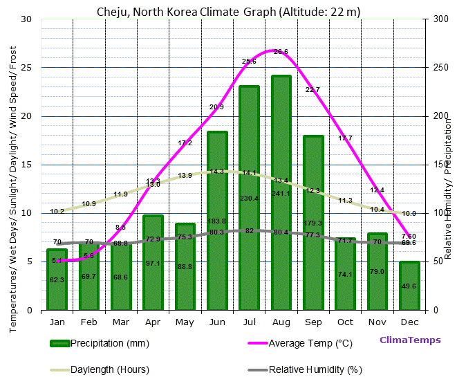
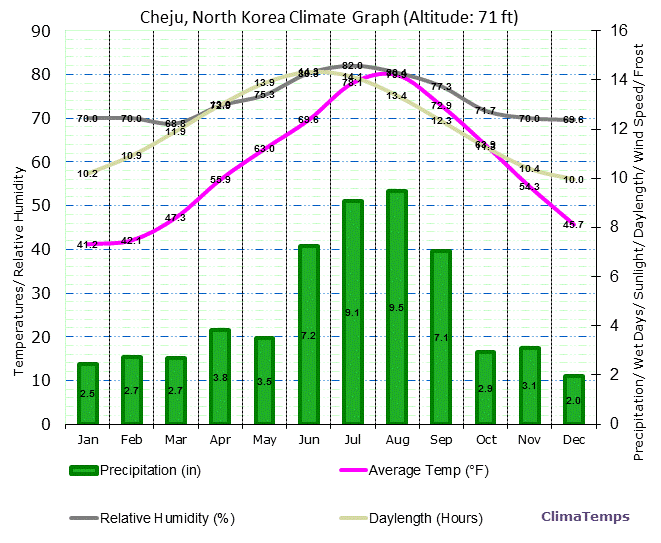
The first graph shows the climate in Cheju, North Korea in metric units and the second in English units.
The climate graphs depict monthly average temperatures, precipitation, wet days, sunlight hours, relative humidity and wind speed.
Cheju Climate Graph in Metric Units
Cheju Climograph in English Units
Cheju Climate Graphs Discussion
 We are pleased to announce the release of the new discussion section. Here you will discover a wealth of knowledge about the various aspects of the local climate presented by our international community. We would like to invite you to help get discussion started by visiting those locations you are familiar with. Is there something noteworthy about the climate there that you can enlighten us about? Discussion is subdivided into specific topics such as the months of the year and aspects such as day length and temperature. When you have an idea of something fascinating to share please visit the specific page most fitting and add your post using the simple interface. No registration or third party network login is necessary. We are pleased to announce the release of the new discussion section. Here you will discover a wealth of knowledge about the various aspects of the local climate presented by our international community. We would like to invite you to help get discussion started by visiting those locations you are familiar with. Is there something noteworthy about the climate there that you can enlighten us about? Discussion is subdivided into specific topics such as the months of the year and aspects such as day length and temperature. When you have an idea of something fascinating to share please visit the specific page most fitting and add your post using the simple interface. No registration or third party network login is necessary.
Climate Graphs for Closest locations to Cheju, North Korea:
|